Thursday, April 19, 2012

Stanley Reservoir via West Monument Creek

date: 04/18/2012
activity: hiking/fishing
distance: 5.5 miles
time: 4 hours

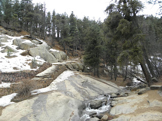
This was my 2nd attempt to reach Stanley Reservoir hiking the West Monument Creek trail. The first time I was turned around due to large amounts of snow and ice in November. The hike was the most difficult, yet most rewarding, hike I have done thus far in Colorado. A physically demanding, albeit short, hike yielded a small and secluded reservoir reached only by foot. Not coincidentally, I was the only person at the resevoir at the time. The reservoir was a photographer (and fishers) paradise. As is my norm, I only caught one fish on this trip. Here is a view of the canyon on the hike in:

(click any picture to enlarge)


The hike itself was strenous, to say the least. The trailhead began at the Air Force Academy at an elevation of 7200 feet. By mile 2, I was already at an elevation of over 8800 feet. A normal 2 mile hike might take 30 to 45 minutes, while this one took over an hour. Fortunately, along the trail were numerous water falls and man made log bridges that were aesthetically pleasing. Over the course of a half mile, there were at least a dozen small and medium sized waterfalls along the trail.


A large snowbank around mile 1.5 almost forced to me turn around. Thankfully, a brave soul had laid red flags along an alternate route up and around the snowbank. While this was the most difficult portion of the trail, it was easier than climbing on snow and ice. If you reach the snowbank and dont see any flags, turn around about 25 feet and they will be on the north side of the trail.


Once arriving at the reservoir, the scenery was breathtaking. There is apparently a parking lot near the resevoir to allow for easier access, but the tough hike was forgotten once I arrived at the water.


I only caught one fish in the reservoir, and unfortunately missed a few more. The trout was caught on a small white Road Runner with a pink tail. I had another near hit when a fish actually jumped out of the water to chase the lure on my retrieval. This is a spot I definitely will be coming back to fish this summer when I have more time and daylight!


An EveryTrail clip that shows the extreme elevation changes and a few additional pictures along the route:

Stanley Reservoir via Monument Creek


Find hiking trails in Colorado

Thursday, March 15, 2012

Cheyenne Mountain

date: 03/04/12 and 03/11/12
activity: hiking, sight-seeing

Cheyenne Mountain is not only home to NORAD, a highly secret defense command built inside the mountain, but also many beautiful water falls. We visited 7 Falls, Helen Hunt Falls, and Mt. Cutler (named after the great quarterback, I suppose). The area also has many small hiking trails, a nice visitors center, and multiple picnic areas. We chose 2 nice, sunny days to explore the area.

The first day, on March 4th, we took a picnic lunch along and went on a few small trails that equaled about 2.5 miles. There was also a small stream running through the area that we explored (unfortunately, no fish!). We had intended on climbing Mt. Cutler, but decided against it. The area also has abundant wildlife, we saw at least 10 mule deer on the days we were there.


On the second trip to the area, along with sister Natalie, we viewed the historic Helen Hunt Falls and took a small hike on a multipurpose 4x4 trail that we shared with motor bikes, mountain bikes, and hikers. The Helen Hunt Falls was mostly frozen over, which gave us the opportunity to watch a group of ice climbers. Even in 55 degree weather the group were using ice picks and crampons to climb straight up a 100 foot waterfall. Heres one of the brave ice climbers...


The view from the top of the falls looked over Colorado Springs and one could see for miles upon miles. Here are a few more pics of the view and one of us:


Map of the area and our first hike:

7 Falls


Find hiking trails in Colorado

Saturday, February 25, 2012

Snowshoeing Roxborough State Park

date: 01/25/12
activity: snowshoeing
distance: 3 miles
time: 1 hour 30 minutes


A beautiful Saturday afternoon in February gave us a perfect opportunity to do a snowshoe hike in scenic Roxborough State Park. Thankfully the warm weather didn't completely melt off the 8 inches of snow we recently received. At the beginning of the trail we followed a few other snowshoe marks through a wooded area (found out later this was not the trail!). We then met up with the trail around mile 1 and followed it to a top of a plateau. At this point we turned around and followed a trail back to the visitors center.


In all, we snowshoed around 3 miles. Roxborough State Park is a very scenic area with 4 or 5 various trails, ranging from 1 to 6 miles. Considering it is a Colorado State Park, there is a $7 entrance fee to enter the park. Due to the warm weather we did not have the best conditions for snowshoeing. I think our next snowshoe hike will be near the Rocky Mountain National Park, allowing for a higher altitude and thus more snow. All in all, this is a State Park I would recommend year-round. 

Enjoy some pictures from the South Rim Trail:


Wednesday, February 8, 2012

Snowshoeing Mitchell Creek Canyon

date: 02/06/2012
activity: snowshoeing
distance: 1.5 miles
time: 45 minutes

A rare Monday off work (for an apartment renovation) allowed me to try out a new, albeit short, snowshoe hike. I did not know exactly what to expect from a trail stemming from a suburban neighborhood. Initially, I walked a paved concrete trail holding the snowshoes in my hand. Thankfully, I found a side trail that required the use of snowshoes due to the 19" of snow Castle Rock just received.

The trail showed some of Castle Rock's scenic ecology and geography. The scenery is nearly the same as the nearby Castlewood Canyon State Park, without the $7 entry fee. The trail hugs the side of the canyon and with the recent snow showed off some massive icicles hanging from the small caves. I stopped at one of the caves, one without dangling overhead icicles, for some beef jerky and hot tea from the thermos. This is the point I turned around and headed back to the truck. The trail seemed to go on much further and is one I will view again when the ice and snow receeds.

Enjoy some pictures...